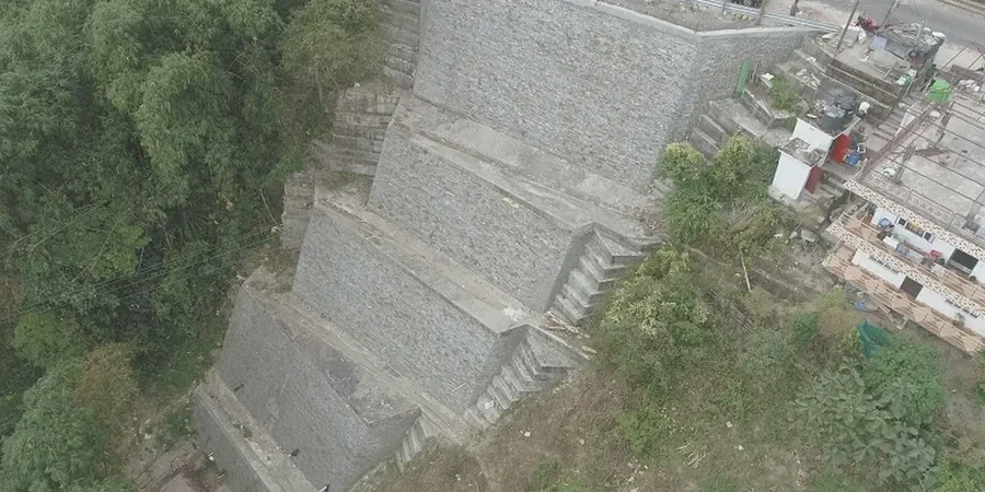
The National Building Code of Canada (NBCC 2020) mandates rigorous geotechnical investigation where a 1V:3H slope or steeper exists within a distance less than twice the slope height from a proposed foundation. In Chilliwack, this isn't just a regulatory checkbox. The city sits squarely on the Fraser River floodplain, ringed by steep Pleistocene and Holocene sediments along Promontory and the eastern benches. Our team has worked enough sites near Chilliwack Mountain and Vedder Mountain to know that a desk-based slope stability assumption can bury a project in liability. The analysis we deliver integrates local groundwater mapping, historic landslide scarps identified on LiDAR, and soil strength data from our accredited laboratory, directly supporting the geotechnical engineer of record with in-situ permeability tests when evaluating perched water tables that often trigger shallow failures in silty colluvium.
In Chilliwack's alluvial fan deposits, ignoring seasonal groundwater fluctuation in a slope model can overestimate the factor of safety by 30% or more.
Our approach and scope
Much of Chilliwack's developable land sits on the Chilliwack River alluvial fan, a depositional feature that has been building for over 10,000 years. This geology creates a layered subsurface of loose sands, silts, and gravels with a shallow groundwater table that fluctuates aggressively between November and April. A standard rotational slip analysis here must account for the rapid dissipation of matric suction during the rainy season, which reduces the apparent cohesion of surficial soils to nearly zero. We run both total stress and effective stress scenarios, using pore pressure coefficients calibrated to local monitoring well data. For cuts deeper than 4 meters in the glaciomarine stony clays found on the eastern slopes of Chilliwack, we also recommend checking the sensitivity of the soil to remolding, as these materials can lose significant strength when disturbed, a detail often missed in generic analyses that only rely on peak friction angles from standard triaxial compressions.
Site-specific factors
Chilliwack's growth since the 1980s has pushed subdivisions further up the lower benches of Vedder Mountain and onto the undulating terrain near Little Mountain. These areas were historically farmed or left as forested slopes, and the shift to residential density introduced surcharge loads from building footings, altered drainage patterns from impermeable roofs and roads, and abrupt cut-and-fill transitions that can destabilize a previously dormant slope. The most common trigger we see in local forensic reviews is not a single heavy storm, but a gradual rise in pore pressure over several wet seasons combined with uncontrolled roof leader discharge at the slope crest. A slope stability analysis that models the long-term build-up of a perched water table, something we do routinely using SEEP/W coupled to SLOPE/W, often reveals that the margin of safety drops below the NBCC threshold within five years of construction if drainage is not properly designed and maintained.
Reference standards
NBCC 2020 (Division B, Section 4.2.4 — Slope Stability), CSA A23.3-14 — Design of Concrete Structures (for associated retaining elements), ASTM D4767-11 — Consolidated Undrained Triaxial Compression Test for Cohesive Soils, BC Supplement to NBCC 2020 (Ministerial Orders M357, M358), ISSMGE Guidelines for Slope Stability Analysis (2019)
Frequently asked questions
How much does a slope stability analysis cost for a residential lot in Chilliwack?
For a typical single-family lot on a moderate slope in Chilliwack, the analysis, including the required soil strength testing and a sealed report, ranges from CA$1.860 to CA$5.250. The range depends on whether we need to install a piezometer for groundwater monitoring over a wet season, the number of cross-sections the municipality requires, and if a seismic displacement analysis is triggered by the proximity to a steep scarp.
Which code governs slope stability in Chilliwack, and does the city have additional requirements?
The primary standard is the BC Building Code 2018, which adopts the NBCC 2015 with provincial variations. The City of Chilliwack's engineering department typically requires a factor of safety of 1.5 for long-term static conditions and 1.1 for pseudo-static seismic loading for any development within a mapped geohazard area, and they often ask for a professional reliance letter from the geotechnical engineer confirming the site is safe for its intended use.
Do I need a slope stability analysis if my property is flat but backs onto a steep ravine?
Yes, this is a classic setback scenario. The NBCC setback guidelines use an influence zone. If your proposed foundation is closer to the ravine crest than twice the ravine depth, the code triggers a stability assessment. We've worked on several homes along the Hope River greenbelt in Chilliwack where this exact condition applied, and a simple cross-section analysis confirmed the required setback and any need for a retaining structure.
What soil tests do you run to get the strength parameters for the slope model?
We target effective stress parameters because long-term drained conditions govern most slope failures in Chilliwack's silty soils. Typically, we run a multi-stage consolidated undrained (CIU) triaxial test with pore pressure measurement per ASTM D4767 on undisturbed Shelby tube samples. For the shallow colluvium, we also run a direct shear test on a remolded sample at the in-situ density, as the peak drained friction angle of this material often controls the shallow infinite slope stability of the surficial layer.
How long does a slope stability study take from start to finish?
A straightforward analysis for a single cross-section can be completed in three to four weeks after the site investigation is done. If the city requires a full wet-season groundwater monitoring program, which is common for larger subdivisions in the Promontory area, the process extends to include data collection from November through March, with the final report delivered in April or May to capture the highest recorded phreatic surface.